
“We’ve seen … an unusually high number of very warm days into the 30s [in Melbourne]. ” Dr King said.
“Obviously, this past month we saw a new joint daily record for Australia, with the 50.7 degrees in northern [Western Australia].”
“As the climate continues to warm, we’re going to see more heat records, we will see more days over 35 [degrees] and more days over 40 as well – that will happen – and also the possibility of days over 45 or even 50 in Melbourne.” he says.
“If we keep emitting greenhouse gases and keep warming the planet, it’s possible that in a few decades’ time … mid-21st century there’s a reasonable chance we’d be having 50-degree days in Melbourne and Sydney.”
Melbourne’s humidity was also at all-time highs in January, with “dew point” readings – which indicate how much moisture is in the air – breaking prior monthly records by a wide margin.
“We measure [humidity] by looking at the dew point temperatures at 9am and 3pm, and they’re well above average due to La Nina, with a lot of moisture coming down from the north,” said Mr How of the bureau.
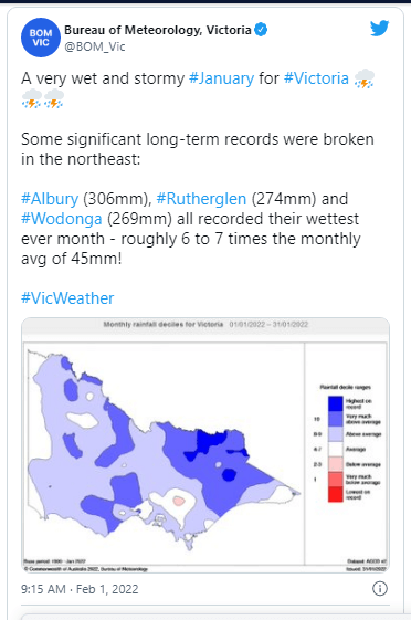
Victoria’s January was the seventh wettest on record, and the wettest since 2011 – the previous time the La Nina weather pattern occurred– with statewide rainfall 90 percent over average.
In January, the state’s north-east received some of the heaviest rainfall on record. Rutherglen and Wodonga both had their wettest ever months, with 274 and 269 millimetres of rain, respectively, which was almost six to seven times the monthly normal of 45 millimetres, according to the bureau.
With 306 mm of rain in a single month, Albury set a new record for rainfall.
In January, Melbourne had 79.6 mm of rain, which is roughly 33 millimetres more than the normal.
“It’s been the reverse scenario, with very dry weather all over the South Australian border,” Mr How said in the state’s far west.
“They’ve received very much below-average rainfall.
“[This summer’s La Nina] helps to explain why it has been wetter than usual, particularly across the east.
“[The weather has been] warm, humid, wet and kind of in line with what we were expecting this summer with La Nina.”
Australia is experiencing a La Nina weather phenomenon, which means colder (but not necessarily freezing) temperatures, more wet days, and a higher danger of storms. El Nino, on the other hand, delivers higher temperatures and less precipitation. Both come from the Pacific Ocean.
Dr. King said that while climate change was likely affecting weather systems such as La Nina and El Nino, the effects were “minor” compared to the effects on heatwaves and heat extremes.
A humid and unstable air mass is expected to generate “heavy” rainfall and destructive gusts, according to the bureau, which issued a severe thunderstorm warning for portions of north-east Victoria on Tuesday.
VicEmergency has issued a “watch and act” advisory, advising residents in places such as Bright, Mount Hotham, and Falls Creek to prepare for possible life-threatening flash floods by taking shelter.
Keep this going please, great job!
my webpage: nordvpn coupons inspiresensation (7ee.ir)
Fastidious replies in return of this matter with
solid arguments and explaining all concerning that.
Review my webpage … nordvpn coupons inspiresensation (http://t.co/vNNQZ7uWLc)
This is my first time go to see at here and i am genuinely pleassant to
read everthing at alone place.
Feel free to surf to my web blog :: nordvpn coupons
inspiresensation (easyurl.cc)
Nordvpn Code 350fairfax
Greetings from Carolina! I’m bored to tears at work so I decided to browse your site on my iphone during lunch break.
I enjoy the info you provide here and can’t wait to take a look
when I get home. I’m shocked at how fast your blog loaded on my cell
phone .. I’m not even using WIFI, just 3G .. Anyhow, amazing
blog!
Good day! Do you know if they make any plugins to protect against hackers?
I’m kinda paranoid about losing everything I’ve worked hard on. Any tips?
my website … eharmony special coupon code 2025
Hello, i think that i saw you visited my web site thus i got here to go back the favor?.I’m trying to to find things to enhance my website!I guess its adequate to use a few of your ideas!!
Also visit my website :: vpn
My brother suggested I might like this blog. He used to be totally
right. This publish truly made my day. You can not believe simply how a lot
time I had spent for this info! Thank you! https://tinyurl.com/2ab5s5qz gamefly
Thanks designed for sharing such a nice thinking, post is nice, thats why i have read it entirely https://tinyurl.com/2xsenm6a what is vpn stand for
Hey very nice blog!
I’m gone to convey my little brother, that he should also go to see this weblog on regular basis to get updated from latest gossip.
I’m not sure why but this blog is loading very slow for me.
Is anyone else having this problem or is it a issue on my
end? I’ll check back later on and see if
the problem still exists. Eharmony special coupon code 2025
https://tinyurl.com/yt83ggsk
Aw, this was an exceptionally nice post. Taking a few minutes and actual effort to make a superb article… but what can I say… I put things off
a lot and never seem to get anything done.
my web site :: https://tinyurl.com/ynhykdhk
https://vk.com/public211532114
Awesome article. https://www.highlandguides.com/ vpn
новостной сайт